|
Station |
km |
Remarks |
Location |
Dist. |
Altit. |
|
Halat Ammar |
8 |
4
arches, ground floor only. Locomotive 110, Hartmann 3545/1911 |
N 29.08'19 E 036.04'51 |
km 591
594 |
705 m
759 m |
|
Crossing 1 |
3 |
south of Halat Ammar. |
N 29.07'15 E 036.05'37 |
km 594 |
707 m |
|
Fort 1 |
2 |
and
side buildings ground floor. |
N 29.06'37 E 036.06'07 |
km 597 |
|
|
Zat el Hajj |
7/12 |
4
arches, ground floor only, water tower double tank, windmill.
|
N 29.02'50 E 036.10'05 |
km 608
610 |
691 m |
|
End of rails |
6 |
heading south. |
N 28.59'58 E 036.12'00 |
km 614 |
|
|
Carriage
|
1,5 |
made in Belgium, dismantled 1998 |
N 28.59'18 E 036.12'17 |
km 616 |
|
|
Fort 2 |
4 |
north of Bir ibn Hermas. |
N 28.57'37 E 036.13'02 |
km 620 |
740 m |
|
Observation post |
|
Post on top of hill with breatwork |
N
28.56’14 E 036.13’49 |
|
|
|
(Crossing) 2 1 |
1 |
|
|
km 622 |
740 m |
|
Bir Hermas |
13/25 |
4
arches ground floor only. One-tank water tower, windmill
|
N 28.51'08 E 036.16'15 |
km 632 |
770 m
744 m |
|
Bridge |
|
bridge over wadi 27 m |
N 28.47'31 E 036.17'26 |
|
|
|
Bridge |
|
bridge over wadi 12 m |
N 28.47'29 E 036.17'26 |
|
|
|
El Hazim |
22 |
4
arches, ground floor only. |
N 28.40'07 E 036.21'00 |
km 654 |
755 m |
|
Makhtab
|
24 |
4
arches, ground floor only |
N 28.29'30 E 036.28'21 |
km 677 |
740 m
750 m |
|
(Crossing) 3 1 |
3 |
|
|
km 681 |
785 m |
|
Bridge |
|
bridge over wadi 32 m |
N 28.25'18 E 036.31'40 |
|
|
|
Tabuk |
11/14 |
complete station with several buildings and workshop. Water tower
double tanks. Station is renovated and partially modified.
|
N 28.23'15 E 036.33'40 |
km 692 |
775 m |
|
Bridge |
|
bridge over wadi 32 m |
N 28.21'24 E 036.36'18 |
|
|
|
(Crossing) 4 1 |
14 |
???
Arqanat ??? |
N 28.18’40 E 036.39’31 ? |
km 706 |
830 m |
|
Bridge |
|
bridge over wadi 12 m |
N 28.17’08 E 036.41’18 |
|
|
|
Al Uthaily
2 |
8/22 |
Small fort (25 men) featuring porch with 3 arches openings
|
N 28.15'09 E 036.43'50
N 28.13'23 E 036.45'48 ? |
km 714
716 |
844 m |
|
Sahr ul Ghul, Birk?
2 |
6/6 |
Small fort (15 men) featuring porch with 3 arches openings. Ground
level construction. Huge ballast stock. |
N 28.13'05 E 036.46'30
N 28.09’30 E 036.51’46 ? |
km 720
737 |
880 m
950 m |
|
Bridge 2 |
5 |
with 10 arches 170 m (Wadi Ghudayy) |
N 28.11'44 E 036.49'16 |
km 725 |
|
|
Bridge 3 |
12 |
with 12 arches (Wadi Ghudday II) |
N 28.07'35 E 036.54'42 |
km 737 |
|
|
Al Awjariyah
Dar ul Hadsch
|
7/24 |
Small fort (15 men) featuring porch with 3 arched openings Ground
level construction. |
N 28.06'20 E 036.57'30 |
km 744 |
950 m
906 m |
|
Al Mustabaghah |
11/11 |
Small fort (25 men) featuring porch with 3 arched openings, secured
by fortifications on the ridges. |
N 28.06'49 E 037.04'00 |
km 755 |
970 m
949 m |
|
Tunnel |
1 |
Entry to the one and only tunnel. |
N 28.06'01 E 037.04'16 |
km 756 |
|
|
El Akhdar |
4/5 |
Small fort (15 men). Building stripped of facing stones, almost
ruined. Deep cistern in front. |
N 28.06,32 E 037.05'31 |
km 760 |
878 m
883 m |
|
Akhdar Alimantasion
3 |
5/5 |
Small fort (25 men). Several overturned rails and at least two
sub-frames of carriages. |
N 28.05'42 E 037.07'58 |
km 765 |
880 m |
|
Bridge 4 |
8 |
12
arches. |
N 28.05'08 E 037.09'24 |
km 773 |
|
|
Two bridges
5 |
3 |
crossing the Wadi, 4 and 16 arches. |
N 28.04'34 E 037.13'43 |
km 776 |
|
|
Khamees
Chamis |
4/15 |
Small fort (25 men) featuring porch with 3 arched openings secured
by fortifications on the ridges. |
N 28.03'55 E 037.15'27 |
km 781 |
909 m |
|
Dschenain el Hadi
Camp |
7 |
Pilgrim's or laborers'. Several round huts with stone foundations.
|
N 28.00'46 E 037.17'31 |
km 788 |
|
|
Disad
Chinzina |
18/25 |
Small fort (15 men) with fortifications on the ridges. |
N 27.53'12 E 037.22'13 |
km 806 |
940 m
964 m |
|
El Muadhem
Qal’at al Mu’azzam |
24/24 |
Small fort (15 men) ground level construction featuring porch with 3
arched openings, housing, water tower 2Tanks. |
N 27.44'15 E 037.31'06 |
km 828 |
1005 m
980 m |
|
(Crossing) 5 1 |
14 |
|
|
km 844 |
1005 m |
|
Khism Sana’a
Chaschim Sanaa |
9/23 |
Small fort (25 men) featuring porch with 3 arched openings. Ballast
stock. |
N 27.32'13 E 037.36'52 |
km 853 |
1060 m
1033 m |
|
Bridge 6 |
2 |
18
arches south of Hasm Sanaa, Hashm San'a |
N 27.31'22 E 037.37'27 |
km 855 |
|
|
(Crossing) 6 1 |
16 |
|
|
km 871
871 |
1120 m |
|
Dar el Hamra
Qal’at al-Buraika |
11/27 |
Small fort (25 men) featuring porch with 3 arched openings. 4
carriages. |
N 27.20'44 E 037.47'57 |
km 880 |
1097 m
1103 m |
|
(El Muteli) 5 |
3 |
Rykat ul Sa’id Pascha ??? Highest point |
N 27.12'58 E 037.53'20 |
km 893 |
1150 m |
|
Muteli
Mutallah |
24/24 |
Small fort (25 men) Building is reconstructed with window openings.
2 carriages. |
N 27.09'29 E 037.52'12 |
km 904 |
1148 m
1151 m |
|
Carriages 2 |
10 |
2
sub-frames of carriages. |
N 27.04'46 E 037.49'34 |
km 914 |
|
|
Abu Taka
2 |
4/14 |
Small fort (25 men) 1 sub-frame of carriage. |
N 26.59'32 E 037.50'34 |
km 918 |
907 m
966 m |
|
(Crossing) 7 1 |
6 |
|
|
km 924 |
830 m |
|
Mabrakat an Naka
2
Al Mazham |
4/12 |
Small fort (25 men) featuring a porch with 3 arched opening. West
wall collapsed following subsequent floods. |
N 26.53'53 E 037.51'37 |
km 930 |
827 m
914 m |
|
Medain Saleh
Madain-Salih |
25/25 |
Main workshops, small fort (25 men) underground stores, housing,
station building. JUNG locomotive No. 60 in workshop + carriages.
Tender No. 2001 next to workshop. Several carriages outside on the
yard. |
N 26.48'22 E 037.56'48 |
km 955 |
820 m |
|
Wadi Hashish
3 |
12/12 |
Small fort (25 men) featuring a porch with 3 arched openings.
|
N 26.42'00 E 037.54'56 |
km 973
973 |
754 m
780 m |
|
Al 'Ula |
7/7 |
Main station, small fort (25 men), windmill, water tower, 3-4
carriages, one of which is almost complete!. Station has been
utilized by locals. |
N 26.36'12 E 037.56'25 |
km 980 |
678 m
681 m |
|
(Crossing) 8 1 |
11 |
|
|
km 994 |
660 m |
|
Bedai
Baday |
6/17 |
Small fort (25 men) featuring porch with 3 arched openings, store,
water tower 2-tanks, windmill, 1 sub-frame of carriage. |
N 26.29'50 E 038.04'77 |
km 999
1003 |
600 m
580 m |
|
Mesched
Mashad |
14/14 |
Small fort (25 men) featuring porch with 3 arched openings. |
N 26.24'37 E 038.10'27 |
km 1012
1013 |
672 m
580 m |
|
Single tender |
2 |
south of Meshad. No. 001 "TO BE USED FOR HEAVY OIL ONLY"
|
N 26.22'55 E 038.12'15 |
km 1013 |
639 m |
|
(Crossing) 9 1 |
12 |
|
N
26.17’41 E 038.16’11 |
km 1024 |
680 m |
|
Seil Matara
2
Sahl al-Matran |
2/14 |
Small fort (25 men) featuring porch with 3 arched openings. 1
carriage south of station. |
N 26.15'54 E 038.18'59 |
km 1025
1034 |
587 m
658 m |
|
Ballast stock |
|
|
N 26.13’01 E 038.23’00 |
|
|
|
Ballast stock |
|
|
N 26.12’17 E 038.23’21 |
|
|
|
Altes Lager |
|
Workmens camp and store near the embanquement |
N 26.11’44 E 038.23.43 |
|
|
|
Zumrud
|
23/23 |
Small fort (25 men) featuring porch with 3 arched openings. Big
stock of ballast. |
N 26.10'29 E 038.25'11 |
km 1049
1048 |
712 m
690 m |
|
Qal’at al Zumrud |
|
Old
fortress |
N
26.10’12 E 038.22’49 |
|
|
|
Ballast stock |
|
Near
Zumrud
station |
N
26.09'28 E 038.25'53 |
km 1048 |
687 m |
|
Bridge |
|
31
m washed around |
N
26.09’13 E 038.25’57 |
|
|
|
Ballast stock |
|
|
N
26.08’58 E 038.25’57 |
|
|
|
Ballast stock |
|
|
N
26.08'22 E 038.25'44 |
|
662 m |
|
Ballast stock |
|
|
N
26.07'36 E 038.26'11 |
|
646 m |
|
Bridge 7 |
|
bridge over Wadi Thaa |
N
26.06'36 E 038.27'09 |
km 1056 |
631 m |
|
Water well |
8 |
and
water tank next to bridge Wadi Thaa |
N 26.06'32 E 038.27'09 |
km 1056 |
631 m |
|
Ballast stock |
|
|
N
26.05'28 E 038.28'05 |
|
641 m |
|
Ballast stock |
|
|
N
26.04'36 E 038.28'48 |
|
637 m |
|
Bridge 8 |
|
bridge over Wadi |
N
26.04'13 E 038.29'07 |
|
637 m |
|
Ballast stock |
|
|
N
26.03'40 E 038.29'36 |
|
647 m |
|
Ballast stock |
|
|
N
26.03'19 E 038.30'27 |
|
666 m |
|
(Crossing) 10 1 |
12 |
|
|
km 1060 |
790 m |
|
Bir Jehid
Ain al-Dschadid |
09/21 |
Small fort (25 men) modified with windows at ground floor. Auxiliary
building and water tower with double tank. 1 carriage. |
N 26.01'34 E 038.33'29 |
km 1072
1079 |
734 m
600 m |
|
Bridge 9 |
|
bridge over Wadi |
N
25.59'56 E 038.34'53 |
|
780 m |
|
Ballast stock |
|
|
N
25.59'17 E 038.35'36 |
|
803 m |
|
Ballast stock |
|
|
N
25.58'41 E 038.35'38 |
|
792 m |
|
Ballast stock |
|
|
N
25.58'15 E 038.35'46 |
|
784 m |
|
Camp |
|
|
N
25.57’12 E 038.36’24 |
|
|
|
Ballast stock |
|
|
N
25.56'47 E 038.36'40 |
|
740 m |
|
Camp |
|
|
N
25.56’18 E 038.36’30 |
|
|
|
Tuire
Tuwaira |
20/20 |
Small fort (25 men). 1 carriage. 2 oven for bred. |
N 25.53'08 E 038.36'38 |
km 1090 |
668 m
430 m |
|
Camp |
|
|
N
25.51’56 E 038.36’58 |
|
|
|
Camp |
|
|
N
25.50’41 E 038.38’03 |
|
|
|
Carriage 3 |
7 |
Sub-frame of carriage Wadi as Sawrah. |
N 25.49'47 E 038.38'50 |
km 1096 |
|
|
Camp |
|
|
N
25.49’23 E 038.39’23 |
|
|
|
Camp |
|
|
N
25.47’49 E 038.40’35 |
|
|
|
Wayban
4 |
6/13 |
Small fort (15 men) of lava stone (dark) one edge destroyed.
10-meter cistern for flat-bed carriages. |
N 25.47'38 E 038.40'43 |
km 1102 |
542 m
400 m |
|
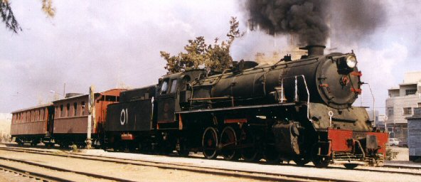
Locomotive 1 |
3 |
No.
157 SLM 1912/2292, one tender, 2 carriages, 1 cubicle cistern, north
of Muderitsch. |
N 25.46'18 E 038.41'81 |
km 1007 |
|
|
Bridge 10 |
|
bridge over Wadi 38 m |
N
25.42'58 E 038.42'02 |
|
|
|
Muderitsch |
9/14 |
Small fort (25 men). |
N 25.41'16 E 038.41'45 |
km 1116 |
452 m
390 m |
|
Camp |
|
|
N
25.40’23 E 038.41’52 |
|
|
|
Bridge 11 |
|
bridge over Wadi 3 arches 20 m |
N
25.37'55 E 038.42'57 |
|
|
|
Bridge 12 |
|
bridge over Wadi 2 arches 10 m |
N
25.37'34 E 038.43'04 |
|
|
|
(Crossing) 11 1 |
11 |
|
|
km 1127 |
345 m |
|
Camp |
|
|
N
25.36’39 E 038.43’16 |
|
|
|
Bridge 13 |
5 |
Biggest bridge over Wadi Al Jizl, 28 arches. 410 m |
N 25.33'01 E 038.44'08 |
km 1132 |
|
|
Observation post |
|
Post on top of hill with breastwork |
N
25.33’04 E 038.43’37 |
|
|
|
Pump station |
|
steam driven pump station near bridge |
N
25.33’00 E 038.44’07 |
|
|
|
Observation post |
|
Post on top of hill with breastwork |
N
25.32’49 E 038.44’04 |
|
|
|
Hedia |
1/17 |
Marshalling station, 2 small forts (15 and 25 men), water tower
double tank, 2 water supplies, triangular rails for shunting. One
complete train on its side with Locomotive No.17 KRAUSS 1904/5238,
one upright train with several open and closed carriages. Several
housings around station |
N 25.32'28 E 038.44'20 |
km 1133
1144 |
400 m |
|
Fortress and camp |
|
Big
fortress and workmen camp left side of cleft, trenches |
N 25.28’11 E 038.47’50 |
|
|
|
Cisterne |
|
Abandoned cisterne near cleft |
N 25.28'18 E 038.47'53 |
|
456 m |
|
Fortress and camp |
|
Big
fortress and workmen camp right side of cleft, trenches |
N 25.28’08 E 038.48’07 |
|
|
|
Dscheda |
21/21 |
Small fort (25 men). Unfinished barracks (100 men). 2 carriages. The
last station built in 1329H. |
N 25.22,42 E 038.48,53 |
km 1155 |
455 m |
|
Observation post |
|
Post on top of hill with breastwork system |
N
25.16’42 E 038.49’32 |
|
|
|
Bridge 14 |
12 |
over Wadi Al Hamd 80 m + 40 m |
N 25.16,33 E 038.49,32 |
km 1166 |
|
|
Bridge 15 |
|
bridge over Wadi 20 m |
N 24.16'18 E 038.49'31 |
|
|
|
Bridge 16 |
|
bridge over Wadi 12 m |
N 24.15'32 E 038.49'26 |
|
|
|
Abu el Na’am |
5/17 |
Small fort (25 men), water tower double tank, barracks (100 men).
Restoration, windows at ground floor. 1 sub-frame. |
N 25.13'46 E 038.49'26 |
km 1173
1176 |
416 m
480 m |
|
Stabal Antar |
17/17 |
Small fort (25 men), and barracks (100 men). |
N 25.05'56 E 038.53'07 |
km 1189
1194 |
535 m
480 m |
|
Bridge 17 |
|
bridge over Wadi 12 m |
N 25.01'26 E 036.56'16 |
|
|
|
Bridge 18 |
|
bridge over Wadi 23 m |
N 25.00'26 E 036.56'56 |
|
|
|
Bridge 19 |
|
bridge over Wadi 15 m |
N 25.00'11 E 036.57'05 |
|
|
|
Bridge 20 |
|
bridge over Wadi 15 m |
N 25.00'06 E 036.57'08 |
|
|
|
Al Buwayr |
20/20 |
2
Small fort (25 men), and barracks (100 men), water tower double
tank, loading dock. One complete train on rails. Locomotive No. 101
HARTMANN 1910/3461, additional tender in the rear. 2 more carriages
closeby. |
N 24.56'52 E 038.59'18 |
km 1208
???? |
462 m
455 m |
|
Bridge 21 |
19 |
before Bir Nasif, 21 arches. |
N 24.51'34 E 039.07'28. |
km 1227
1228 |
481 m |
|
Bir Nasif |
1/20 |
Small fort (25 men), and damaged barracks (100 men). |
N 24.51'09 E 039.07'40 |
km 1228
1245 |
486 m
520 m |
|
Bridge
22 |
|
before Buwatah, .. arches. |
N 24.50'27 E 039.08'38. |
|
502 m |
|
Buwatah
4 |
19/19 |
Small fort (25 men), barracks (100 men). |
N 24.42'07 E 039.13'06 |
km 1247
1273 |
527 m
560 m |
|
Bridge
23 |
|
3
bridges crossing wadi 25 m + 38 m + 17 m |
N 24.37'25 E 039.15'42 |
|
|
|
Hafireh
Qal’at al Hafirah |
20/20 |
Small fort (25 men), barracks (150 men), water tower single tank.
|
N 24.35'27 E 039.21'34 |
km 1268
1290 |
542 m
600 m |
|
Bridge
24 |
|
bridge crossing small wadi 15 m |
N 24.31'37 E 039.26'49 |
|
|
|
Ballast |
|
|
N 24.31’04 E 039.27’08 |
|
|
|
Muteid
Qal’at Machit |
17/17 |
Small fort (25 men), barracks (150 men) auxiliary forts on the
surrounding hills. Last station before Medina. |
N 24.29'51 E 039.28'10 |
km 1287
1303 |
731 m
630 m |
|
(Bir Osman) 5 |
12 |
|
|
km 1297
1315 |
660 m |
|
Medina |
3/15 |
Main station, main workshop. Water tower with 4 tanks. 4
locomotives, several carriages at the end of the yard. Hartmann
No.54 1907/3094, No. 105 1910/3465, No. 111 1912/3546 and SLM No.
151 1912/2286, No. 158 1912/2293. |
N 24.27'43 E 039.35'56 |
km 1302
1320 |
700 m |